11 September 2026 · Model intervals for 1 June 2023 · Research result
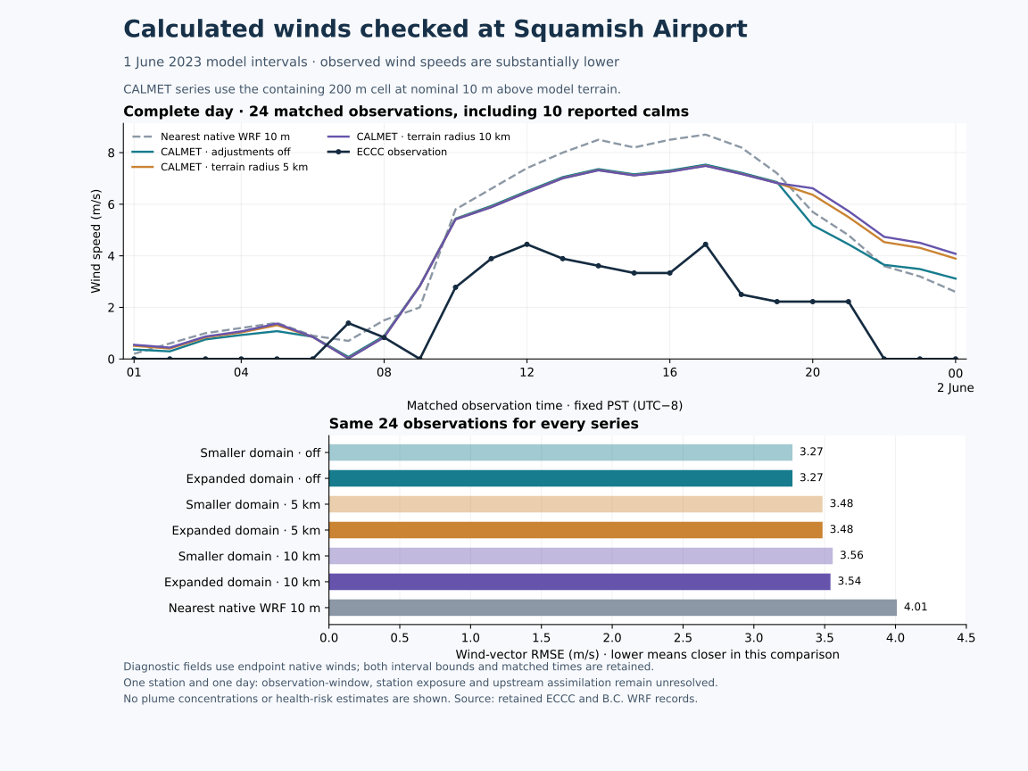
The calculated winds substantially overestimate airport wind speed during this day. Adding 10 km of surrounding terrain changes the airport comparison only slightly. Observed speed averages 1.71 m/s, compared with 4.01–4.28 m/s across the six CALMET cases. The result identifies a problem to investigate before these winds can support flare-exposure estimates across Howe Sound and Squamish.
The same 24 observations are used for every comparison, including 10 reported calms. The station cell and full-day period were fixed before calculating errors. No hours or model settings were selected because they performed well. An independent calculation reproduced every paired value and summary from the retained native records.
The original 20.2 km square and expanded 40.2 km square use the same 200 m spacing and unchanged inputs in their shared area. Each domain has three cases: terrain adjustments off, or the tested terrain adjustments enabled with a 5 km or 10 km search radius. “Off” still includes interpolation and other diagnostic processing; it is not the unprocessed WRF wind. See the full-area domain comparison.
| Wind series | Mean speed, m/s | Mean speed difference, m/s | Speed RMSE, m/s | Wind-vector RMSE, m/s |
|---|---|---|---|---|
| Original domain · adjustments off | 4.01 | +2.30 | 2.78 | 3.27 |
| Expanded domain · adjustments off | 4.01 | +2.30 | 2.78 | 3.27 |
| Original domain · 5 km radius | 4.22 | +2.51 | 3.01 | 3.48 |
| Expanded domain · 5 km radius | 4.22 | +2.51 | 3.01 | 3.48 |
| Original domain · 10 km radius | 4.28 | +2.57 | 3.09 | 3.56 |
| Expanded domain · 10 km radius | 4.27 | +2.55 | 3.07 | 3.54 |
| Nearest native WRF 10 m reference | 4.44 | +2.72 | 3.23 | 4.01 |
Mean difference is calculated minus observed speed. RMSE measures the size of errors; wind-vector RMSE includes both horizontal components and therefore reflects speed and direction. Every row has 24 speed and vector pairs. The native WRF reference samples a different, coarser point and uses its surface-wind field; it is useful context, not a controlled change to a single CALMET process.
At the airport, expanding the domain leaves the off and 5 km cases exactly unchanged. For the 10 km case, wind-vector RMSE falls by just 0.016 m/s. The terrain-adjusted cases have larger errors than the off case on this day. One station and one day cannot establish which configuration is most suitable for the airshed, and no setting has been tuned or adopted on this basis.
Direction is assessed only when both observed and calculated speed are at least 1 m/s. The same 12 timestamps qualify for all seven series. Mean absolute direction error is 27.46° for the off cases, 28.91° for the 5 km cases, 29.20° / 29.14° for the original/expanded 10 km cases, and 35.38° for the native WRF reference. All errors in this particular cohort are at most 90°. Threshold sensitivities at 0.5 and 2 m/s, their denominators and shared cohorts are included in the downloads. A calm observation has no meaningful direction.
The airport's containing model cell is selected by coordinates. Its centre is about 104 m from the retained station position, with model terrain 56.0 m above the model's elevation reference. The calculated wind is at nominal 10 m above that model terrain. No height, exposure or spatial correction was fitted. The nearest native WRF point is about 778 m away, with 22 m model terrain and 1.333 km spacing. Station-specific June 2023 sensor height, exposure and sampling-window history remain unverified.
Pam Rocks lies 3.87 km south of the expanded grid. It is omitted because no model cell covers the station; no edge value or extrapolation substitutes for it. This airport check is one meteorological diagnostic within an assessment for all communities. It does not validate winds at the flare, over the water, at altitude or throughout the valley. The community coverage audit separately addresses where concentration receptors are needed.
Source-code inspection resolved the time alignment. Each saved CALMET record describes an hourly interval, while the native wind interpolation targets its end. The comparison therefore uses observations from 1 June 2023 at 09:00 UTC through 2 June at 08:00 UTC, inclusive. In fixed PST (UTC−8), those are 01:00 on 1 June through midnight at the start of 2 June. The model's interval is 00:00–24:00 on 1 June in fixed PST; daylight-saving civil time is not substituted.
The precise quantity is a diagnostic wind field for the interval, driven by endpoint native wind. Thermal calculations also use the interval midpoint and temperature history, so this is neither an established hourly-mean wind nor a guarantee of an instantaneous measurement-equivalent field. Earlier exported hour_fixed_PST values of 0–23 identify interval starts. Their model-to-model comparisons remain valid, but those labels should not be matched directly to observations. The new paired records include explicit UTC interval bounds and the matched observation time.
The inspected CALMET 6.5.0 branch inserts true-north wind-from inputs as U/V components without a UTM meridian-convergence correction, then applies diagnostics using projected grid geometry. We use that direct convention for this comparison and do not add another WRF or UTM rotation. It should not be described as a rigorous earth-relative transformation.
The native-profile reader also uses a fixed 0.5 m roughness length when logarithmically extrapolating below the first valid profile level. That implementation assumption is distinct from the model cell's surface roughness. Its contribution at the relevant interpolation points must be traced before attributing this speed error to it; changing a parameter to fit this one day would not establish validity.
The enlarged domain supplies more surrounding terrain but does not resolve the demonstrated airport speed mismatch. The next useful work is to trace the low-level wind treatment, qualify station exposure and timing, and test source-site, shoreline and elevated winds across inflow, outflow, weak-wind and reversal episodes. Vertical temperature observations are required to test an inversion diagnosis. The expanded vertical-wind audit separately examines persistent large terrain-following W values.
These observations may have contributed to the upstream WRF analysis; that participation is unknown. This is a consistency comparison, not independent physical validation. It produces no pollutant concentrations or health-risk estimates. Community exposure modelling still requires linked flare release inputs, suitable transport and chemistry, representative background air and explicit receptor heights under common criteria throughout the area.
Independent review reproduced 168 pairs, seven summaries, 42 direction/cohort rows and 4,320 profile values directly from CALMET records, ECCC numeric tokens and native WRF surface records. No discrepancies were found; the largest angular arithmetic difference was 5.68 × 10⁻¹⁴ degrees. This verifies extraction and calculations, not weather accuracy.
Primary inputs: ECCC June 2023 airport observations, ECCC hourly-data schema, and the B.C. native WRF tile containing the airport reference. Source-code version, hashes and exact line locators are retained in the checks and methods archive.