6 September 2026 · Historical weather experiment · 1 June 2023, fixed PST (UTC−8)
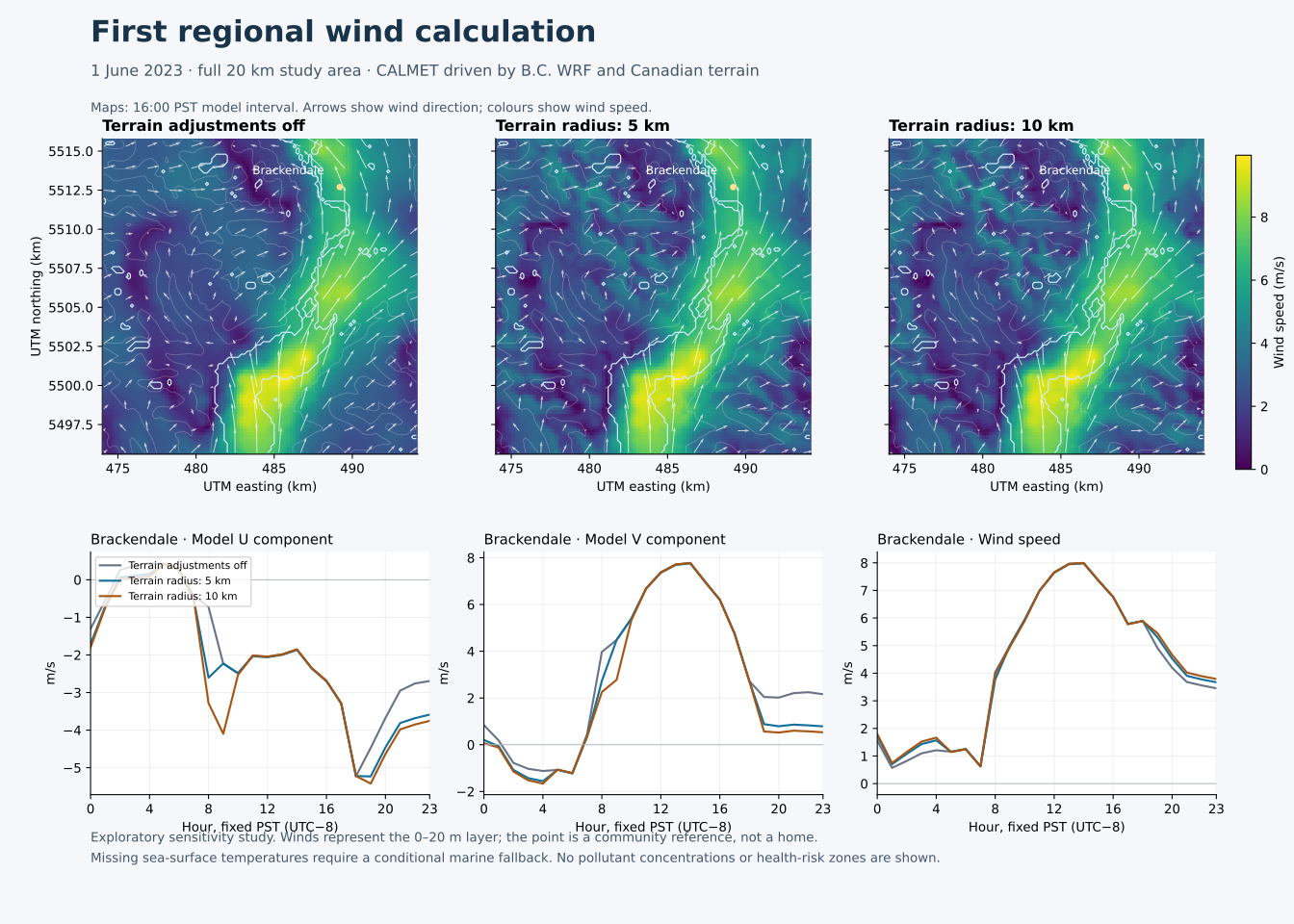
CALMET has now calculated a complete day of winds over the full study area. Three runs compare the same regional weather with terrain blocking and slope-flow adjustments switched off, then switched on with two terrain search distances. This is a first test of the regional weather calculation, not a pollutant release or neighbourhood exposure prediction.
The maps show the 16:00 PST model interval, chosen before viewing the calculated fields. Colours represent wind speed, and arrows show model wind direction. The lower panels show all 24 intervals at the existing Brackendale reference point. That point represents a place label, not a particular home or a neighbourhood average. Larger vector figure
| Comparison | Mean wind-vector difference over the day | Largest interval difference |
|---|---|---|
| Terrain adjustments off → 5 km terrain radius | 0.53 m/s | 2.26 m/s |
| Terrain adjustments off → 10 km terrain radius | 0.77 m/s | 3.08 m/s |
| 5 km → 10 km terrain radius | 0.24 m/s | 2.53 m/s |
A vector difference includes changes in direction as well as speed. These are differences between calculations; they are not errors measured against observations. The results show that a terrain setting can materially change the wind at this reference point during some intervals. They do not establish which setting is more accurate or whether a Woodfibre plume reaches Brackendale.
The terrain radius controls how far the diagnostic model searches for surrounding terrain features. Both values were selected before calculating winds, within the typical range described in B.C.’s guidance. Neither has been established as the correct local value. Across the entire lowest layer and day, the two terrain-radius cases differ by an average of 0.15 m/s, with a maximum of 4.40 m/s. B.C. modelling guideline, Tables 6.1–6.2
The calculation uses the checked 101 × 101 grid at 200 m spacing, Canadian elevation and land cover, and six adjoining B.C. WRF tiles. Ten vertical layers extend to 3,000 m above model terrain. The lowest layer spans 0–20 m, with a nominal wind calculation height of 10 m above model terrain. It is not an integrated layer mean or a two-metre concentration calculation. Regional surface inputs, B.C. weather data service
Every sea-surface-temperature value in the selected 25 native states is zero: 15,000 surface records, including all 2,050 records in the provisional native water category. These zeros cannot serve as physical water temperatures. Preparation stopped before the planned sea-temperature option was run.
The completed experiment therefore uses CALMET’s documented option for prognostic lapse rates with a neutral air–water temperature-difference fallback when marine observations are absent. This assumption is explicit. No overwater mixing or surface-flux prediction is claimed. The native land-use taxonomy also remains unconfirmed; the converter’s hard-coded category count cannot establish it. Provider control and reader documentation
All three runs completed their 24 intervals. Output parsing checked every record boundary and 22,034,160 wind values, with no non-finite values. The unchanged model processed the regional hourly weather records successfully. These are computational checks, not independent meteorological validation.
The stored terrain-following vertical component reaches approximately 11 m/s in the terrain cases. It should not be interpreted directly as an Earth-vertical downdraft. Follow-up equation checks explain the stored values, and two additional runs identify terrain blocking as the main driver of the largest excursion. The same review shows that Brackendale’s terrain searches are cut short by the current grid boundary. A larger domain and physical evaluation are needed before transport modelling. Wind-driver and domain-support follow-up The model’s precipitation-radius reset warning and the unsuccessful control-preparation attempts are retained in the checks record.
Next priorities are usable marine temperatures, a justified vertical grid and physical domain buffer, and comparison with suitable observed winds and vertical temperature profiles. This first summer day does not establish winter inversion or outflow performance. Current linked flare emissions and individual VOC composition remain separate requirements for concentration estimates.
The existing interactive plume explorer retains its illustrative status. This weather study does not change its chemical concentrations or community colours.