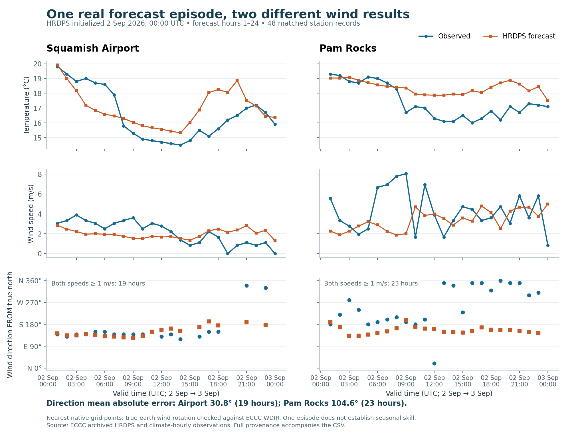
The selected HRDPS forecast has a large wind-direction mismatch at Pam Rocks, despite a smaller mismatch at Squamish Airport. Its nearest grid point to the Woodfibre shoreline is also much too elevated to use directly as a site forecast. These findings come from one real 24-hour forecast episode. They are a meteorological comparison, not validation of the dispersion model or a prediction of flare impacts.
The forecast is the operational continental HRDPS 2.5 km cycle initialized at 00:00 UTC on 2 September 2026, forecast hours 1–24, valid from 2 September 01:00 UTC through 3 September 00:00 UTC, inclusive. It was chosen because its dated archived fields and complete matching observations were available, before inspecting the forecast errors. It is not presented as a severe-pollution or representative-season episode.
Each exact filename was checked against the actual dated ECCC directory listing before downloading. We acquired 10 m U/V wind and 2 m temperature at each forecast hour, independent wind speed/direction fields at hours 1, 12 and 24, and three pressure-level profiles plus surface references at hour 12. The resulting 92 GRIB2 files total 219,461,500 bytes and remain in work/hindcast-2026/. A compact hash and URL manifest permits packaging the evidence without including those large raw files. Verified dated archive directory, HRDPS provider documentation
Both stations have 24/24 matched temperature, wind-speed and wind-direction records, with null flags for these variables in the retrieved ECCC climate-hourly records. These recent records may be revised; null flags are not a claim of final manual quality assurance. The comparison CSV contains all 48 pairs, conversions and errors. Full original observation features are preserved in the work folder, and station metadata accompanies the result. ECCC climate-hourly collection
Errors below are forecast minus observation. Temperature and speed scores use all 24 hours per station. Direction error is the shortest signed angular difference, wrapped into −180° to +180°, with mean absolute error reported. Direction scoring requires both observed and forecast speeds to be at least 1 m/s; this analysis choice avoids interpreting calm or very weak wind bearings. Vector error includes all hours and uses both true east and true north components.
| Metric | Squamish Airport | Pam Rocks |
|---|---|---|
| Temperature mean absolute error | 1.14 °C | 1.10 °C |
| Temperature bias | +0.45 °C | +0.97 °C |
| Wind-speed mean absolute error | 1.07 m/s | 2.17 m/s |
| Wind-speed bias | −0.13 m/s | −0.92 m/s |
| Wind vector root mean square error | 1.74 m/s | 6.31 m/s |
| Wind-direction mean absolute error | 30.8° | 104.6° |
| Eligible direction hours | 19 / 24 | 23 / 24 |
| Observed calm hours | 2 | 0 |
The small airport speed bias does not mean its hourly wind is accurate: positive and negative errors cancel. At Pam Rocks, the forecast fails to reproduce much of the observed direction change. The broad difference persists if the direction threshold changes: at 0.5 m/s, the directional errors are 36.9° and 104.6°; at 2 m/s, 13.7° and 112.9°, but only 4 airport and 18 Pam Rocks hours remain. These are episode-specific diagnostics, not estimates of general forecast skill.
The extraction uses the nearest native forecast grid point, without interpolation, bias correction or station-elevation adjustment. ECCC station elevation is the station's metadata elevation, not a verified wind-sensor height. Sensor mounting height, local exposure and exact observation averaging periods still require station-history review.
| Location | Observation/site coordinates | Native forecast coordinates | Distance | Station or site elevation | Forecast orography |
|---|---|---|---|---|---|
| Squamish Airport, climate 10476F0; WMO 71207 | 49.783208, −123.161194 | 49.788064, −123.153120 | 0.792 km | 53.7 m, ECCC metadata | 107.3 m |
| Pam Rocks, climate 10459NN; WMO 71211 | 49.487780, −123.299453 | 49.481496, −123.305272 | 0.815 km | 7.1 m, ECCC metadata | 3.0 m |
| Woodfibre map proxy | 49.665253, −123.254185 | 49.665604, −123.270152 | 1.150 km | Approximately 9 m, legacy CDEM point check | 568.4 m |
The Woodfibre point is an existing site map proxy, not a flare coordinate or observed weather station. Its nearest forecast point is west of the shoreline on elevated terrain. The roughly 559 m elevation difference is much larger than the distinction between the legacy elevation reference and model orography. It demonstrates a serious representativeness problem, not an appropriate lapse-rate correction by itself. Prior terrain evidence, ECCC station metadata source
The extracted point-forecast CSV retains this Woodfibre proxy result for inspection, explicitly marked as an unvalidated point with a terrain mismatch. It should not drive a shoreline flare calculation as if it were measured or representative source wind. The other two stations' comparisons do not remove that limitation.
All comparisons join on the provider's UTC_DATE and the GRIB valid time. The observation API query has a buffer around the target day; the returned dates, not assumptions about the URL, determine membership. ECCC LOCAL_DATE is fixed PST, UTC−8, even in summer. No daylight-saving adjustment is applied to that field.
The decoded forecast fields have GRIB stepType=instant. A forecast valid at 12:00 UTC is therefore not a mean over 11:00–12:00. Climate-hourly winds can be short averages near the nominal timestamp, commonly 2 or 10 minutes; the exact station-specific interval for these September observations was not verified. We compare the reported times as the available surface-weather check and do not call the result a comparison of full-hour wind means. Temperature is likewise compared at its reported time. No hourly air-pollutant means enter this comparison. ECCC authors' wind-observation methods discussion
Observed wind speed is converted from km/h by dividing by 3.6; direction is converted from tens of degrees by multiplying by 10. Observed calm direction is undefined and left empty. Forecast temperature is converted from kelvin to °C. Every file's GRIB initialization, valid date/time and resulting lead were checked; these files store the raw forecastTime in minutes, while the filenames and output CSV use hours.
The grid is a rotated latitude–longitude grid, 2540 × 1290 points, with 0.0225° increments, southern pole −36.08852°, 245.305142°, zero additional rotation, and uvRelativeToGrid=1. Simply treating its U/V fields as true east/north would be incorrect. We rotate using the pole geometry at each native grid point; the exact formula, original grid components and rotation coefficients are retained in the provenance JSON.
As an independent check, derived direction and speed were compared with ECCC's separately distributed WDIR and WIND at all three points at hours 1, 12 and 24. The largest differences were 0.595° and 0.011 m/s, consistent with finite packing precision. The rotation also preserves vector magnitude and has unit-length basis coefficients. No direction sign or magnetic-north adjustment was guessed.
GeoMet's subset service was investigated first, but its advertised reference-time range at retrieval began on 4 September, excluding this cycle. Consequently the dated GRIB archive was used; a current forecast was not substituted. The advertised range and service responses are preserved. GeoMet time/subset documentation
The profile CSV contains forecast temperature, wind and geopotential height at 985, 950 and 925 hPa, valid at 12:00 UTC on 2 September, at each of the three extracted points. It contains no measured upper-air profile. Pressure-level heights are in geopotential metres; model surface orography is in metres. Their difference is reported only as an approximate height above model terrain, not a surveyed geometric height above ground.
At the Woodfibre proxy's elevated model point, surface pressure is 940.93 hPa. The 985 and 950 hPa levels are below the model surface and are marked unusable as atmospheric samples there. Only the sampled 925 hPa level passes the pressure and height checks. Three pressure levels at one hour cannot establish the local inversion depth, turbulence or plume-height wind; below-ground values must not be interpolated into a source profile.
This comparison provides a working, reproducible weather-data pipeline and demonstrates two concrete failure modes to investigate: spatially different wind errors within Howe Sound and a severe source-grid terrain mismatch. Before using such fields for a defensible Woodfibre prediction, obtain local source-site observations, select terrain-appropriate meteorological treatment, and validate across independent inflow, outflow, low-wind and transition episodes and seasons. Do not tune a correction to this one day and call the resulting field validated.
The source activity, dispersion, chemistry and ambient-objective workstreams remain separate. None was evaluated by this forecast-versus-weather comparison.